The KKRT & BVRT: Brisbane (via train to Gympie) – Kilkivan – Nanango – Toogoolawah – Brisbane
The Kilkivan to Kingaroy Rail Trail (KKRT) and Brisbane Valley Rail Trail (BVRT) are, in aggregate, the longest rail trail routes in Australia. The problem with rail trails? They are one way! But, these can be combined into a long-weekend loop. If you have a bit of a sense of adventure it can be done in a way that does not require a pick-up and drop-off to/from Brisbane. And, as proven on this trip, all you need is four days when conditions are terrible. So when they are good, four days should be ample!
Day 1: Brisbane – Kilkivan


Brisbane seems to be a relatively recent convert to allowing bicycles on commuter trains. Well done you Brissie! This opens up the ability to travel quite some distance with your bike for a very reasonable price. And, a few times a day, this includes all the way to Gympie.
Currently, there is an extremely convenient train leaving Brisbane CBD around 0930 and arriving in Gympie just over 3 hours later. This proved to be simple and no fuss, but I confess to having been a little nervous as to whether there would be other cyclists and hence limited space on the train. Given this, I chose to board at Roma Street (rather than Central) – making sure I was on the train at its ‘departure station’. Here I met a retired couple also taking the same train with bikes: their intention was to spend an indeterminate time exploring north of Gympie, and were packed with camping gear in panniers. Jealous of their flexibility (whilst also relieved not to be carrying that much kit), I sensed their own nervousness on whether we would “all” get on the train. Whilst they made a beeline to the front of the platform I sought out some station staff for advice. Extremely friendly, they indicated that there should be no issue – head to either the front or end of the train. Choosing the end, I had things pretty much to myself, including ready access to one of the on-train toilets.
The start to my trip happened be on quite a damp day, so I chose to stop for lunch in Gympie in the hope the rain would ease a little. The centre of town is about 3.5km from the station, and you can pass the historic central station (no longer in regular use) on your ride into town. From here, I had made the choice to try and minimise highway cycling – particularly avoiding the Bruce Highway.


My initial route took the Gympie-Woolooga Road. This proved to be a very pleasant option. Early-on there is regular traffic but this quickly becomes less common the further you get from Gympie and the forested scenery gives way to farmland views. Sadly no koalas spotted despite the signs.


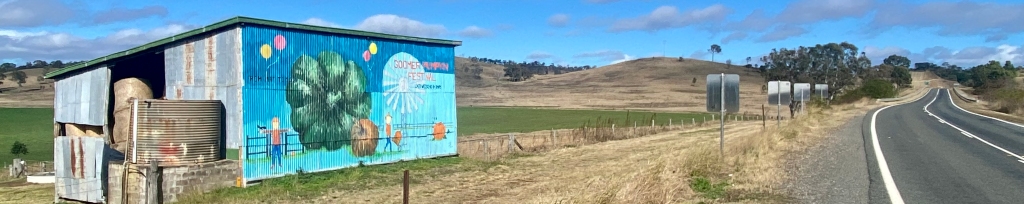
Approximately 24km from Gympie the small village of Widgee (where there is a petrol station if you need a human refuel) denotes a change in the nature of the road – narrower in parts and even less traffic. This is what back-road cycling should be like. As you can see, it remained damp for this part of the trip – on a dry day I imagine it would be even more stunning. Sadly, however, to get to Kilkivan you do need to do a final stretch on the Wide Bay Highway.


Regular readers of this site would know of my goal of avoiding highways and main roads wherever this is possible and sensible. It just isn’t fun to regularly have high-speed traffic (particularly trucks) passing you on a bike – unless there is a massive verge. And let’s face it – Australian highways are not well known for being terribly well endowed with spare width. Sometimes, however, it is just unavoidable and the final 21km on the Wide Bay Highway was exactly that – unless there is something I’m missing. Thankfully, the route was ok – some verge, regular but not constant traffic (allowing for all passers-by to give a wide berth), and some nice views to match. And an odd blue tree on descent into town….


Day 2: Kilkivan – Nanango


Someday I would love to be able to cycle the full Kilkivan to Kingaroy rail trail. It does seem, however, that the first part of the KKRT is in need of a major upgrade. The KKRT is initially unsealed, and more than that it seems to be more fire track than trail. These sections were closed when I visited, and it was easy to see why – they were extremely muddy in parts and flooded in others. It would be lovely to see the whole trail upgraded to a condition where it is rare that it is not navigable. Based upon what I could see these would be the most challenging parts of the entire KKRT/BVRT trails even when conditions are dry. And this was such a contrast to the sealed parts of the KKRT, which typically were much better than the BVRT.


Until the trail is upgraded, backroad options to Goomeri seem limited. Research indicated a requirement to either take a complete trip on the Wide Bay Highway, or extending the route a little by taking the ~14km available via Kilkivan-Tansey Road and Cinabar Road. These are very pleasant backroads that also can have their own floodwater challenges, but the over road water was limited when I passed. Even with this back road route there is still a requirement for another 15km of the Wide Bay Highway to Goomeri where there are a number of options for coffee.


Being totally over highway cycling by now, after a short trip on the Bunya Highway I was keen to take some backroads to Murgon – hoping that from there I could use the sealed rail trail. Thankfully, Manyung Road followed by Hethringtons Road offered a really scenic route through farmland and rolling hills. Some of the hill top views were well worth the climb.


I didn’t linger in Murgon as my plan was to have some lunch in Wondai. Initially I was really delighted and surprised as to the quality of the rail trail. It has been built to a high quality and is a real pleasure to ride. Unfortunately the crossing at Barambah creek was heavily under water and I had to completely back-track to Murgon. I was surprised by how much water was across the trail – it normally is a crossing that is well above water (as can be seen in this blog). This then led to a re-plan and (unfortunately) a return to the highway.


Returning to Murgon, I was determined to try and find a way to minimise highway travel. I gave Ferris Road a try, and thankfully despite the Barambah Creek flooding and a reasonable amount of on-road water, it was ok to cycle. The worst area – on the right of the gallery below, was walkable without getting soggy shoes. That’s a win.


After some more Bunya Highway travel (not terrible, not great), and some so-so lunch in Murgon it was time to rail trail. And the KKRT delivers. It is just lovely. The 30km stretch is slightly uphill but it is sealed, where a creek or crossing exists there is a bridge, and there are interesting farm views. If only the whole trail (and frankly the BVRT) was like this! High quality stuff.


At the end of the trail you arrive at the old Kingaroy train station, pretty much in the middle of town. As a person of a particular generation, there are two things I associate with Kingaroy: Joh Bjelke-Petersen and peanuts. Many farms on the rail trail seem to be peanut farms, so it would be a crime not to visit The Peanut Van and get pretty much any flavour of peanut that takes your fancy. Salted Caramel for me – a nice treat in an afternoon break.


A well thought-through piece of infrastructure of these rail trails is the Link Trail – a connection to get to the BVRT that is helpfully sign-posted. Comprising a collection of sealed and unsealed backroads through to Nanango, this was both well marked and also a very nice trip.


The first half is sealed, and the hilly part. It offers excellent views. There is then a transition to gravel before the final run into Nanango. Overall this is smooth and pleasant gravel, and the crossing at the intersection of Semgreen and Kunioon Roads seemed to be one that would be cycleable in almost all conditions (as were a few over-road water patches on Kunioon Road). After all this, I was very glad for a beer and bed in Nanango.


Day 3: Nanango to Toogoolawah


Having seen the impact of the rain on the trail to this point, I was quite nervous about heading off on the remainder of the link trail – from Nanango through to Yarraman. I had read that this trail was more of a track, could be rough, and that the Yarraman Creek crossing could be deep after rain. Given my experience in preceding days I chose to attempt another route, but was not keen on yet more highway cycling the whole way to Yarraman.


Hazeldean Road, followed by Nanango – Neumgna Road, proved to be scenic ridge-top routes that ran broadly parallel to the highway and reduced the need to travel by main road. It did not, however, prove error free (as you will see from my Komoot). To get back to the highway I got a little lost and I thought about a few different options. The route (Rocky Creek Road) that ultimately took me back to the D’Aguilar Highway was a bit track-like but absolutely rideable. I was glad that it was only 5.5km of highway cycling to reach Yarraman.


Refueled with coffee, I setoff on the rail trail to Blackbutt. Things started off promisingly, with the trail in good condition, the cuttings relatively water free, and parts of the trail showing the benefits of major repairs from flooding earlier in the year. However things went downhill from there, with difficult crossing and mud that was truly awful in parts, and not great in others.


Cooyar Creek was just passable. Using my bike to find the stepping stones, I was able to creep across despite the pretty swift water. I coincidentally ran into a trail ranger at the pub in Toogoolawah (The Exchange) – he was very surprised that I had crossed and not trespassed on the local farmer’s property to get to the highway bridge and then back to the trail at Harland Park (apparently quite a few do and it is a source of some tension).
From Cooyar Creek to Blackbutt the trail suffered from a lack of drainage in the cuttings. Unlike most the rest of the trail where the trail had been raised in the middle with hard pack gravel, these were curated mud puddles. The mud made for slippery and difficult cycling – something that proved too much for a number of others I passed and unfortunately had led a few to take a fall. Be careful.


During a clean up and refuel in Blackbutt, I had the opportunity to ask about conditions on the trail towards Moore. I was very relieved to hear that it was much better, and so it proved. The trail was a mix of different surfaces and also travelled through State Forest as well as past and through farmland. It is also pretty much one long downhill section followed by a run across plains.
Moore is a perfect lunch stop with a number of options available on the main street. From here the trail also continues to be in good condition in general, but there are a few remaining creek and swamp areas to navigate. These do illustrate some of the challenges that arise when a trail does not retain a raised run as the previous rail line did – things work fine if it is dry, not so much in the wet.


I was very glad that I had amended my plan to end in Toogoolawah rather than continue on to Esk on this day (see my comments below on accommodation and flexibility). Overall it had proven to be quite hard work given the trail conditions. Having said that, the trail between Moore and Toogoolawah was the easiest of the day by a long way. The photos show just how varied the BVRT is in both the surface and also the work done to deal with crossings. It was doubly surprising as in my experience trails running through livestock paddocks are often in poor condition. Not here – just expect some slightly random company from the cattle at times.


Day 4: Toogoolawah to Brisbane


My four days on the rail trails offered a range of weather – wet day one, cold in the morning day three (given the elevation) and day four brought fog. This made for an atmospheric run between Toogoolawah and Esk, which involves a climb up and then descent down into Esk.


A similar climb and descent follows between Esk and Coominya, and this provided some of the most beautiful farm views of the whole trip. Here you do feel a bit away from it all, and this perception is also reinforced by the two major creek crossings on the route – at Sandy Creek and Logan Creek. Yet again the variability of the preparation and infrastructure that has gone into the trail was on show. I kind of get differences when travelling between different council areas, but I really don’t understand why the Sandy Creek crossing was so difficult when compared to the one nearby at Logan Creek.


Heading on towards Lowood the trail flattens out, and predominantly passes between and through cattle farms. If you are thinking about whether to stop in Coominya or continue onto Lowood, the 11km between the two can be done pretty quickly and there is a broader range of options for food and coffee in Lowood.


From Lowood there is a run beside the Brisbane River and through and around properties that indicate you are getting closer to Brisbane. Increasingly I also passed walkers on the trail – some day trippers and also those out for a walk from home. Surprisingly the trail closest to Ipswich was also of a poorer level of quality – fire-trail style prior to the connection to the Brassall Bikeway – concrete path.


Once you get to Ipswich it is possible to catch the train – I cycled down to Wulkuraka station to check it out. But what is the fun in that? The trick, though, is to figure out a route that doesn’t subject you to running beside a freeway all the way to the Brisbane CBD.


After a bakery refuel in East Ipswich (recommended), I thought it would be fun to take the Moggill Ferry – free for cyclists. This does allow you to continue cycling where you feel it isn’t the city – instead it seems to be a place where horse paddocks, river views and large gardens are the order of the day.


I confess that this route was an experiment and it led to some hills. Lots of short and sharp ups and downs, both in Pinjarra Hills and also in Kenmore before joining the cycle path to the CBD. If this is not for you, maybe stick to freeway bike paths. Or look at the route contours a bit more closely than I did.


Despite the hills, it was much nicer than the Western Freeway Cycleway. Don’t get me wrong: the path is fine but suffers from the same issue faced by other freeway paths (eg M7 in Sydney) – proximity to traffic. It is noisy and at times you have to cross roads where it is not ideal (something that the M7 shared path does much better). But it does take you to the city.


When you get close to the CBD and run parallel to the river on the Bicentennial Bikeway things are much nicer. Sure, there is more on-path traffic but the views are good, the infrastructure is good, and it provides for a number of options for exiting to where you need to go. A nice way to finish an epic ride.


Tips, recommendations and things I’d change
There is no doubt that my ride was affected by the weather, and yours could be too. Significant parts of Day 2 and Day 3 had to be replanned (sometimes on the fly!) because of the weather in the preceding week. I’d love to return when it had been dry for a while to see what the unsealed section of the KKRT was like, be able to cross Barambah Creek between Murgon and Wondai, and to fully follow the Kingaroy to Yarraman link trail. I found some facebook sites useful (eg KKRT and Friends of BVRT) as they could give a “heads up” as to some issues, although they were not reliable sources of real time status such as for creek flooding.
Having said that, it is totally worth having a plan. I searched the “official sites” (BVRT and KKRT) and also found the guide published by Gillian Duncan and Mark Roberts to be extremely useful.
The other thing I’d change is the trail infrastructure. In some parts it is tremendous (I’m thinking of you KKRT between Murgon and Kingaroy). In others, a lack of investment, planning or common sense (all three?) was missing. When you compare these trails to Tumbarumba-Rosewood and the Murray to Mountains, KKRT and BVRT are nowhere near the standard of those trails. This doesn’t mean that it has to be sealed, but a lack of drainage, sensible crossings and hard-packed surfaces make for less than optimal cycling in the dry, and unpleasant travel in the wet. Given the patronage I observed, perhaps there isn’t the compelling case for further upgrades as things seem well frequented. I think this is a missed opportunity to maximise the support and benefit for the communities through which the trails run.
Cafes, pubs and other things


The three nights on the trail were a mixed bag accommodation-wise. I was told a number of times that I was a bit crazy in only organising one night ahead – apparently things do get booked up. With that in mind I would suggest booking in Kilkivan given the limited options (the Kilkivan Hotel Motel was ok, but nothing to really get excited about). The best hotel by a mile was the Exchange Hotel in Toogoolawah – a single room was only $65 per night including a basic breakfast, dinner was great, and the staff were just lovely.


On the topic of coffee and food I stopped quite a few times on the trip for a refuel. The more memorable ones that are worth seeking out were Soma Soma in Gympie (excellent coffee), Yarramarnos in Yarraman (a very cycling aware and friendly place to stop), and Kai Lounge in Moore (great organic food and unlimited fresh water, which is not available in the toilet block). In addition:
- Readers of other CyclingGravel content would know I’m a fan of a good bakery mid-ride. Pies are great, but it is also cool to find an awesome Vietnamese for Banh Mi. The Saigon Bakery East Ipswich is highly recommended.
- When I cycled past the Linville Hotel it looked really pumping. Talking to some others on the trail it seems it often has live music and a great reputation. If it makes sense for you check it out (I plan to next time!).
Finally, a word on the train from Brisbane to Gympie. Brisbane has not yet caught up with world-leading public transport ticketing systems where you can use your credit card instead of the local smartcard (eg Opal, Oyster). However there are significant benefits for having a Gocard (for Brisbane bus/train travel) as this made for a significantly cheaper fare than buying the paper option ($16.68 vs $30.20). Well worth looking into even if you are in Brisbane for a short time.

Leave a comment